Matthew O'ReganProfessor i marin geologi
Om mig
Forskningsprojekt
 closing in the 4 million years preceding the EOT.
The location of core Site 647 is indicated with the yellow star.")

 or possibly older. These plankton types do not live in the modern Central Arctic Ocean. Scale bars are 100 µm. Photo Credit: Helen Coxall")
Publikationer
I urval från Stockholms universitets publikationsdatabas
-
The Holocene dynamics of Ryder Glacier and ice tongue in north Greenland
2021. Matt O'Regan (et al.). The Cryosphere 15 (8), 4073-4097
ArtikelLäs mer om The Holocene dynamics of Ryder Glacier and ice tongue in north GreenlandThe northern sector of the Greenland Ice Sheet is considered to be particularly susceptible to ice mass loss arising from increased glacier discharge in the coming decades. However, the past extent and dynamics of outlet glaciers in this region, and hence their vulnerability to climate change, are poorly documented. In the summer of 2019, the Swedish icebreaker Oden entered the previously unchartered waters of Sherard Osborn Fjord, where Ryder Glacier drains approximately 2 % of Greenland's ice sheet into the Lincoln Sea. Here we reconstruct the Holocene dynamics of Ryder Glacier and its ice tongue by combining radiocarbon dating with sedimentary facies analyses along a 45 km transect of marine sediment cores collected between the modern ice tongue margin and the mouth of the fjord. The results illustrate that Ryder Glacier retreated from a grounded position at the fjord mouth during the Early Holocene (> 10.7±0.4 ka cal BP) and receded more than 120 km to the end of Sherard Osborn Fjord by the Middle Holocene (6.3±0.3 ka cal BP), likely becoming completely land-based. A re-advance of Ryder Glacier occurred in the Late Holocene, becoming marine-based around 3.9±0.4 ka cal BP. An ice tongue, similar in extent to its current position was established in the Late Holocene (between 3.6±0.4 and 2.9±0.4 ka cal BP) and extended to its maximum historical position near the fjord mouth around 0.9±0.3 ka cal BP. Laminated, clast-poor sediments were deposited during the entire retreat and regrowth phases, suggesting the persistence of an ice tongue that only collapsed when the glacier retreated behind a prominent topographic high at the landward end of the fjord. Sherard Osborn Fjord narrows inland, is constrained by steep-sided cliffs, contains a number of bathymetric pinning points that also shield the modern ice tongue and grounding zone from warm Atlantic waters, and has a shallowing inland sub-ice topography. These features are conducive to glacier stability and can explain the persistence of Ryder's ice tongue while the glacier remained marine-based. However, the physiography of the fjord did not halt the dramatic retreat of Ryder Glacier under the relatively mild changes in climate forcing during the Holocene. Presently, Ryder Glacier is grounded more than 40 km seaward of its inferred position during the Middle Holocene, highlighting the potential for substantial retreat in response to ongoing climate change.
-
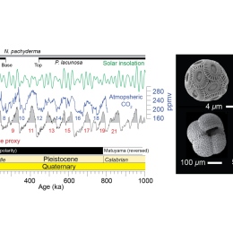
Calcareous nannofossils anchor chronologies for Arctic Ocean sediments back to 500 ka
2020. Matt O'Regan (et al.). Geology 48 (11), 1115-1119
ArtikelLäs mer om Calcareous nannofossils anchor chronologies for Arctic Ocean sediments back to 500 kaPoor age control in Pleistocene sediments of the central Arctic Ocean generates considerable uncertainty in paleoceanographic reconstructions. This problem is rooted in the perplexing magnetic polarity patterns recorded in Arctic marine sediments and the paucity of microfossils capable of providing calibrated biostratigraphic biohorizons or continuous oxygen isotope stratigraphies. Here, we document the occurrence of two key species of calcareous nannofossils in a single marine sediment core from the central Arctic Ocean that provide robust, globally calibrated age constraints for sediments younger than 500 ka. The key species are the coccolithophores Pseudoemiliania lacunosa, which went extinct during marine isotope stage (MIS) 12 (478-424 ka), and Emiliania huxleyi, which evolved during MIS 8 (300-243 ka). This is the first time that P lacunosa has been described in sediments of the central Arctic Ocean. The sedimentary horizons containing these age-diagnostic species can be traced, through lithostratigraphic correlation, across more than 450 km of the inner Arctic Ocean. They provide the first unequivocal support for proposed Pleistocene chronologies of sediment from this sector of the Arctic, and they constitute a foundation for developing and testing other geochronological tools for dating Arctic marine sediments.
-
Stratigraphic Occurrences of Sub-Polar Planktic Foraminifera in Pleistocene Sediments on the Lomonosov Ridge, Arctic Ocean
2019. Matt O'Regan (et al.). Frontiers in Earth Science 7
ArtikelLäs mer om Stratigraphic Occurrences of Sub-Polar Planktic Foraminifera in Pleistocene Sediments on the Lomonosov Ridge, Arctic OceanTurborotalita quinqueloba is a species of planktic foraminifera commonly found in the sub-polar North Atlantic along the pathway of Atlantic waters in the Nordic seas and sometimes even in the Arctic Ocean, although its occurrence there remains poorly understood. Existing data show that T. quinqueloba is scarce in Holocene sediments from the central Arctic but abundance levels increase in sediments from the last interglacial period [Marine isotope stage (MIS) 5, 71-120 ka] in cores off the northern coast of Greenland and the southern Mendeleev Ridge. Turborotalita also occurs in earlier Pleistocene interglacials in these regions, with a unique and widespread occurrence of the less known Turborotalita egelida morphotype, proposed as a biostratigraphic marker for MIS 11 (474-374 ka). Here we present results from six new sediment cores, extending from the central to western Lomonosov Ridge, that show a consistent Pleistocene stratigraphy over 575 km. Preliminary semi-quantitative assessments of planktic foraminifer abundance and assemblage composition in two of these records (LOMROG12-7PC and AO16-5PC) reveal two distinct stratigraphic horizons containing Turborotalita in MIS 5. Earlier occurrences in Pleistocene interglacials are recognized, but contain significantly fewer specimens and do not appear to be stratigraphically coeval in the studied sequences. In all instances, the Turborotalita specimens resemble the typical T. quinqueloba morphotype but are smaller (63-125 mu m), smooth-walled and lack the final thickened calcite layer common to adults of the species. These results extend the geographical range for T. quinqueloba in MIS 5 sediments of the Arctic Ocean and provide compelling evidence for recurrent invasions during Pleistocene interglacials.
-
Arctic closure as a trigger for Atlantic overturning at the Eocene-Oligocene Transition
2019. David K. Hutchinson (et al.). Nature Communications 10
ArtikelLäs mer om Arctic closure as a trigger for Atlantic overturning at the Eocene-Oligocene TransitionThe Eocene-Oligocene Transition (EOT), approximately 34 Ma ago, marks a period of major global cooling and inception of the Antarctic ice sheet. Proxies of deep circulation suggest a contemporaneous onset or strengthening of the Atlantic meridional overturning circulation (AMOC). Proxy evidence of gradual salinification of the North Atlantic and tectonically driven isolation of the Arctic suggest that closing the Arctic-Atlantic gateway could have triggered the AMOC at the EOT. We demonstrate this trigger of the AMOC using a new paleoclimate model with late Eocene boundary conditions. The control simulation reproduces Eocene observations of low Arctic salinities. Subsequent closure of the Arctic-Atlantic gateway triggers the AMOC by blocking freshwater inflow from the Arctic. Salt advection feedbacks then lead to cessation of overturning in the North Pacific. These circulation changes imply major warming of the North Atlantic Ocean, and simultaneous cooling of the North Pacific, but no interhemispheric change in temperatures.
-
Early Holocene sea level in the Canadian Beaufort Sea constrained by radiocarbon dates from a deep borehole in the Mackenzie Trough, Arctic Canada
2018. Matt O`Regan (et al.). Boreas 47 (4), 1102-1117
ArtikelLäs mer om Early Holocene sea level in the Canadian Beaufort Sea constrained by radiocarbon dates from a deep borehole in the Mackenzie Trough, Arctic CanadaDeglacial and Holocene relative sea level (RSL) in the Canadian Beaufort Sea was influenced by the timing and extent of glacial ice in the Mackenzie River corridor and adjacent coastal plains. Considerable evidence indicates extensive ice cover in this region of northwestern Canada during the Late Wisconsinan. However, no absolute ages exist to constrain maximum RSL lowering before the late Holocene (4.2-0ka). In 1984, the Geological Survey of Canada drilled an 81.5-m-deep borehole in the western Mackenzie Trough at 45m water depth (MTW01). The lower 52.5m of the borehole was interpreted as a deltaic progradational sequence deposited during a period of rising sea level. The upper 29m was described as foraminifer-bearing marine sediments deposited after transgression of the site, when RSL rose above similar to-74m. Here, we present radiocarbon measurements from MTW01, acquired from benthic foraminifera, mollusc fragments and particulate organic carbon in the >63m fraction (POC>63m) in an attempt to constrain the chronology of sediments within this borehole and date the timing of transgression. The deepest carbonate macrofossil was acquired from 8m above the transgressive surface (equivalent to 21m b.s.l.), where mollusc fragments returned a date of 9400 +180-260cal. a BP (2 sigma). This provides the oldest constraint on Holocene sea-level lowering in the region, and implies that transgression at this site occurred prior to the early Holocene. Ages obtained from the lower 52.5m of the borehole are limited to POC>63m samples. These indicate that progradational sediments were deposited rapidly after 24820 +390-380cal. a BP (2 sigma). Due to the incorporation of older reworked organic matter, the actual age of progradation is likely to be younger, occurring after Late Wisconsinan glacial ice retreated from the coast.
-
The De Long Trough
2017. Matt O'Regan (et al.). Climate of the Past 13 (9), 1269-1284
ArtikelLäs mer om The De Long TroughIce sheets extending over parts of the East Siberian continental shelf have been proposed for the last glacial period and during the larger Pleistocene glaciations. The sparse data available over this sector of the Arctic Ocean have left the timing, extent and even existence of these ice sheets largely unresolved. Here we present new geophysical mapping and sediment coring data from the East Siberian shelf and slope collected during the 2014 SWERUS-C3 expedition (SWERUS-C3: Swedish - Russian - US Arctic Ocean Investigation of Climate-Cryosphere-Carbon Interactions). The multibeam bathymetry and chirp sub-bottom profiles reveal a set of glacial landforms that include grounding zone formations along the outer continental shelf, seaward of which lies a > 65m thick sequence of glacio-genic debris flows. The glacial landforms are interpreted to lie at the seaward end of a glacial trough - the first to be reported on the East Siberian margin, here referred to as the De Long Trough because of its location due north of the De Long Islands. Stratigraphy and dating of sediment cores show that a drape of acoustically laminated sediments covering the glacial deposits is older than similar to 50 cal kyr BP. This provides direct evidence for extensive glacial activity on the Siberian shelf that predates the Last Glacial Maximum and most likely occurred during the Saalian (Marine Isotope Stage (MIS) 6).
-
Modeling fracture propagation and seafloor gas release during seafloor warming-induced hydrate dissociation
2017. Christian Stranne, Matthew O'Regan, Martin Jakobsson. Geophysical Research Letters 44 (16), 8510-8519
ArtikelLäs mer om Modeling fracture propagation and seafloor gas release during seafloor warming-induced hydrate dissociationThe stability of marine methane hydrates and the potential release of methane gas to the ocean and atmosphere have received considerable attention in the past decade. Sophisticated hydraulic-thermodynamic models are increasingly being applied to investigate the dynamics of bottom water warming, hydrate dissociation, and gas escape from the seafloor. However, these models often lack geomechanical coupling and neglect how overpressure development and fracture propagation affect the timing, rate, and magnitude of methane escape. In this study we integrate a geomechanical coupling into the widely used TOUGH+Hydrate model. It is shown that such coupling is crucial in sediments with permeability 10(-16)m(2), as fracture formation dramatically affects rates of dissociation and seafloor gas release. The geomechanical coupling also results in highly nonlinear seafloor gas release, which presents an additional mechanism for explaining the widely observed episodic nature of gas flares from seafloor sediments in a variety of tectonic and oceanographic settings.
-
Surface heat flow measurements from the East Siberian continental slope and southern Lomonosov Ridge, Arctic Ocean
2016. Matt O'Regan (et al.). Geochemistry Geophysics Geosystems 17 (5), 1608-1622
ArtikelLäs mer om Surface heat flow measurements from the East Siberian continental slope and southern Lomonosov Ridge, Arctic OceanSurface heat flow data in the Arctic Ocean are needed to assess hydrocarbon and methane hydrate distributions, and provide constraints into the tectonic origins and nature of underlying crust. However, across broad areas of the Arctic, few published measurements exist. This is true for the outer continental shelf and slope of the East Siberian Sea, and the adjoining deep water ridges and basins. Here we present 21 new surface heat flow measurements from this region of the Arctic Ocean. On the Southern Lomonosov Ridge, the average measured heat flow, uncorrected for effects of sedimentation and topography, is 574 mW/m(2) (n=4). On the outer continental shelf and slope of the East Siberian Sea (ESS), the average is 5710 mW/m(2) (n=16). An anomalously high heat flow of 20328 mW/m(2) was measured at a single station in the Herald Canyon. With the exception of this high heat flow, the new data from the ESS are consistent with predictions for thermally equilibrated lithosphere of continental origin that was last affected by thermotectonic processes in the Cretaceous to early Cenozoic. Variability within the data likely arises from differences in radiogenic heat production within the continental crust and overlying sediments. This can be further explored by comparing the data with geophysical constraints on sediment and crustal thicknesses.
-
Seafloor cratering and sediment remolding at sites of fluid escape
2015. Matt O'Regan (et al.). Geology 43 (10), 895-898
ArtikelLäs mer om Seafloor cratering and sediment remolding at sites of fluid escapeEpisodic fluid escape from marine sediments results from overpressure development and pressure release, and can occur slowly through geologic time or catastrophically. Morphological features in regions of fluid seepage include doming, mud volcanism, cratering, and pockmark formation. Vertical sediment mobilization and surface erosion are considered the principal mechanisms for these topographic changes. However, the impact of mobilization on the geotechnical properties of sediments has not been explicitly considered. Here we develop a one-dimensional numerical subsidence model that incorporates the well-established behavior of remolded fine-grained cohesive sediments. We use this to show that if subsurface overpressure results in the mobilization of sediments, large settlements (20%-35% reduction in volume) can occur when overpressure dissipates. This presents a novel mechanism to explain changes in seafloor and subsurface topography in areas of fluid escape, while highlighting an important interplay between subsurface fluid flow and the geotechnical properties of fine-grained cohesive sediments.
-
Arctic Ocean glacial history
2014. Martin Jakobsson (et al.). Quaternary Science Reviews 92, 40-67
ArtikelLäs mer om Arctic Ocean glacial historyWhile there are numerous hypotheses concerning glacial interglacial environmental and climatic regime shifts in the Arctic Ocean, a holistic view on the Northern Hemisphere's late Quaternary ice-sheet extent and their impact on ocean and sea-ice dynamics remains to be established. Here we aim to provide a step in this direction by presenting an overview of Arctic Ocean glacial history, based on the present state-of-the-art knowledge gained from field work and chronological studies, and with a specific focus on ice-sheet extent and environmental conditions during the Last Glacial Maximum (LGM). The maximum Quaternary extension of ice sheets is discussed and compared to LGM. We bring together recent results from the circum-Arctic continental margins and the deep central basin; extent of ice sheets and ice streams bordering the Arctic Ocean as well as evidence for ice shelves extending into the central deep basin. Discrepancies between new results and published LGM ice-sheet reconstructions in the high Arctic are highlighted and outstanding questions are identified. Finally, we address the ability to simulate the Arctic Ocean ice sheet complexes and their dynamics, including ice streams and ice shelves, using presently available ice-sheet models. Our review shows that while we are able to firmly reject some of the earlier hypotheses formulated to describe Arctic Ocean glacial conditions, we still lack information from key areas to compile the holistic Arctic Ocean glacial history.
-
Glacial geological implications of overconsolidated sediments on the Lomonosov Ridge and Yermak Plateau
2010. Matt O'Regan, Martin Jakobsson, Nina Kirchner. Quaternary Science Reviews 29 (25-26), 3532-3544
ArtikelLäs mer om Glacial geological implications of overconsolidated sediments on the Lomonosov Ridge and Yermak PlateauWith the coupled use of multibeam swath bathymetry, high-resolution subbottom profiling and sediment coring from icebreakers in the Arctic Ocean, there is a growing awareness of the prevalence of Quaternary ice-grounding events on many of the topographic highs found in present water depths of <1000 m. In some regions, such as the Lomonosov Ridge and Yermak Plateau, overconsolidated sediments sampled through either drilling or coring are found beneath seismically imaged unconformities of glacigenic origin. However, there exists no comprehensive analysis of the geotechnical properties of these sediments, or how their inferred stress state may be related to different glacigenic processes or types of ice-loading. Here we combine geophysical, stratigraphic and geotechnical measurements from the Lomonosov Ridge and Yermak Plateau and discuss the glacial geological implications of overconsolidated sediments. The degree of overconsolidation, determined from measurements of porosity and shear strength, is shown to result from consolidation and/or deformation below grounded ice and, with the exception of a single region on the Lomonosov Ridge, cannot be explained by erosion of overlying sediments. We demonstrate that the amount and depth of porosity loss associated with a middle Quaternary (
 790–950 thousand years ago – ka) grounding on the Yermak Plateau is compatible with sediment consolidation under an ice sheet or ice rise. Conversely, geotechnical properties of sediments from beneath late Quaternary ice-groundings in both regions, independently dated to Marine Isotope Stage (MIS) 6, indicate a more transient event commensurate with a passing tabular iceberg calved from an ice shelf.
 -
History of sea ice in the Arctic
2010. Leonid Polyak (et al.). Quaternary Science Reviews 29 (15-16), 1757-1778
ArtikelLäs mer om History of sea ice in the ArcticArctic sea-ice extent and volume are declining rapidly. Several studies project that the Arctic Ocean may become seasonally ice-free by the year 2040 or even earlier. Putting this into perspective requires information on the history of Arctic sea-ice conditions through the geologic past. This information can be provided by proxy records from the Arctic Ocean floor and from the surrounding coasts. Although existing records are far from complete, they indicate that sea ice became a feature of the Arctic by 47 Ma, following a pronounced decline in atmospheric pCO(2) after the Paleocene-Eocene Thermal Optimum, and consistently covered at least part of the Arctic Ocean for no less than the last 13-14 million years. Ice was apparently most widespread during the last 2-3 million years, in accordance with Earth's overall cooler climate. Nevertheless, episodes of considerably reduced sea ice or even seasonally ice-free conditions occurred during warmer periods linked to orbital variations. The last low-ice event related to orbital forcing (high insolation) was in the early Holocene, after which the northern high latitudes cooled overall, with some superimposed shorterterm (multidecadal to millennial-scale) and lower-magnitude variability. The current reduction in Arctic ice cover started in the late 19th century, consistent with the rapidly warming climate, and became very pronounced over the last three decades. This ice loss appears to be unmatched over at least the last few thousand years and unexplainable by any of the known natural variabilities.
Visa alla publikationer av Matthew O'Regan vid Stockholms universitet