Ny artikel i Paleoceanography and Paleoclimatology
The Late Miocene-Early Pliocene Biogenic Bloom in the Eastern Equatorial Pacific: New Insights From Integrated Ocean Drilling Program Site U1335
Daniele Reghellin, Helen K. Coxall, Gerald R. Dickens, Simone Galeotti, Jan Backman, 2022. The late Miocene-early Pliocene biogenic bloom in the eastern Equatorial Pacific: New insigts from Integrated Ocean Drilling Program Site U1335. Paleoceanography and Paleoclimatology, 37(3), 1–16.
http://dx.doi.org/10.1029/2021PA004313
Abstract
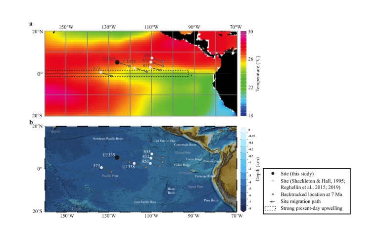
The late Miocene-early Pliocene “biogenic bloom” (BB) manifests as greatly enhanced biogenic sedimentation in sites along the Equator that has been linked to cooler sea surface temperature (SST) in the eastern equatorial Pacific (EEP). However, the full extent and geometry of the BB in the EEP is less known. To improve on this, we have generated new carbonate content (CaCO3%) and bulk carbonate stable isotope (δ13C and δ18O) records spanning the last 7 Ma at IODP Site U1335, located ca. 5° north of the Equator and to the west of the EEP. Site U1335 δ13C and δ18O records display high-frequency variations coupled to changes in sediment composition and physical properties comparable to patterns seen at on-Equator sites further east. During the late Miocene and the early Pliocene bulk δ18O is higher at Site U1335 compared to two off-Equator sites further east, suggesting cooler SSTs generated by stronger equatorial upwelling reaching northwest of the modern core-equatorial upwelling belt. Enhanced upwelling at Site U1335 is supported by relatively higher sedimentation rates prior to 4.6 Ma, symptomatic of higher biological production during the BB. These observations suggest that during the BB the equatorial upwelling circulation was more focused and less parallel to the Equator compared to present day
Senast uppdaterad: 2 mars 2022
Sidansvarig: Institutionen för geologiska vetenskaper