Heading for Greenland to study melting glaciers
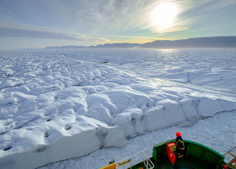
In August, the icebreaker Oden will go to northern Greenland's hard-to-reach waters. Researchers on board will study how much and how rapidly melting glaciers can contribute to raising global sea levels.
At the beginning of August, Swedish icebreaker Oden will leave the port of Thule in northwest Greenland with about 40 researchers on board from ten universities and research institutes in Sweden, the USA, Denmark, Australia and Switzerland. Oden will be at sea over six weeks before she returns to Thule or Longyearbyen on Svalbard. The ice situation can be very difficult in northern Greenland and the adjacent Arctic Ocean, so the expedition needs several alternative routes. The primary geographical focus region of the expedition named North of Greenland 2024 is Victoria Fjord, into which CH Ostenfeld glacier drains. The research plan includes studies of various aspects of the frozen surface of the Earth (the cryosphere), such as its history and development regarding future climate change. The expedition is part of a broader research programme, the North Greenland Earth-Ocean-Ecosystem Observatory (GEOEO).
Melting glaciers affect sea level
The focus is on investigating how much and how fast the ice sheet in North Greenland can contribute to the global sea-level rise. Knowledge is currently unsatisfactory about what happens when glaciers meet the sea and become seawater through melting. It is important to know in more detail how these processes are going and at what speed, mainly in order to be able to develop scenarios for how much the global sea level will rise in a warmer climate. This knowledge is also important for climate models.
Scientific leaders from Stockholm University
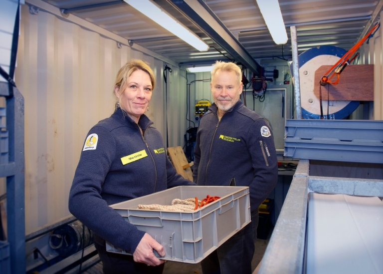
The expedition is coordinated by the Swedish Polar Research Secretariat. The two scientific leaders of the expedition are at Stockholm University. They are Martin Jakobsson, professor of marine geology and geophysics, and Nina Kirchner, professor of glaciology. Of the eleven research groups on board, seven are led from Stockholm University. About half of the researchers participating in the expedition work at Stockholm University and are active in areas such as marine geology, geophysics, geochemistry, glaciology, oceanography and palaeogenetics (ancient DNA). What they have in common is that their research is linked to the cryosphere – historically, today and in the future.
Part of a larger study of Greenland's glaciers
This summer's expedition will be the third with Oden to northern Greenland and is part of the larger research theme GEOEO, where questions about the processes that affect glaciers' interaction with the sea are at the centre. Martin Jakobsson has led the two previous expeditions, Petermann 2015 and Ryder 2019, together with American colleagues. This summer's expedition will take the researchers to the C.H. Ostenfeld glacier, which drains into Victoria Fjord and has almost completely lost its floating so-called ice tongue after it began to break up in 2002.
"The two previous expeditions have been very successful, but far from without challenges. During the Ryder 2019 expedition, we were the first ship ever to enter the Sherard Osborn Fjord where Ryder Glaciers reach the sea. Our mapping of the seabed showed that there is a shallower area in front of the glacier's current location inside the fjord. Our oceanographic measurements show that this shallow area blocks some warmer seawater from reaching the glacier and melting it from below. This may be a main explanation for why the Ryder Glacier has not lost as much as the nearby Petermann Glacier in recent decades. This is the type of information we need to be able to improve our projections of the development of the Greenland ice sheet in a warmer climate and thus the contribution to global sea level rise," says Martin Jakobsson.
Autonomous vehicle to go under the ice
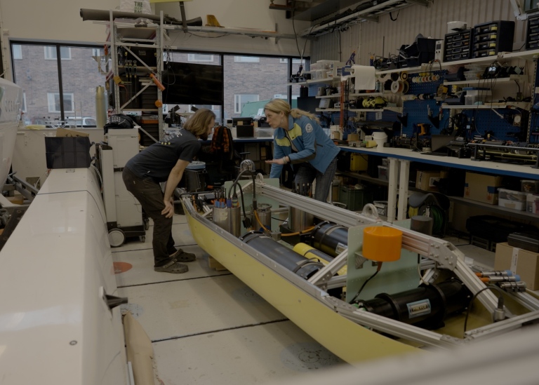
Nina Kirchner is the other scientific leader of the expedition. Her research on board Oden is focused on glacier tongues located along the coast of northern Greenland, such as the Petermann Glacier and the Ryder Glacier that were the targets of previous expeditions, and the C.H. Ostenfeld Glacier that is the focus of GEOEO. On board Oden, Nina Kirchner has instruments and vehicles that will help to examine and visualize the parts of the glacier that are usually hidden from the human eye, or are too dangerous to study up close. These are the outermost edge of the glacier tongue towards the fjord, and where large icebergs can break off (so-called calving of icebergs), the part of the glacier tongue that is below the surface of the water, and the water pocket that is between the seabed and the last pieces of the glacier tongue.
An autonomous underwater vehicle, developed at KTH Royal Institute of Technology, will go under the ice tongue to carry out unique measurements in an environment that is otherwise completely inaccessible. At the same time, the thickness and internal structure of the ice tongue will be examined using an ice radar mounted on a helicopter. All these measurements will be of great importance in the context of numerical models. It is another way to make the inaccessible available, and the only way to forecast future sea level rise.
"The final preparations and tests for the expedition are in full swing. I am very much looking forward to the expedition itself starting! If nothing unforeseen happens to all the instruments, sensors and vehicles, we will come home with unique data from an area that can be seen as a key area for the stability of the North Greenland Ice Sheet, and that is fantastic. But that's not the end, because then we start to feed this data into numerical models, which can then provide better forecasts of future sea level rise," says Nina Kirchner.
DNA studies of bones and teeth
Photo: Beth Shapiro
In addition to research on board Oden and in the sea around the icebreaker, a research group led by palaeogeneticist Love Dalén at Stockholm University will collect samples on land. The researchers will look for bones and teeth from animals. They will also take bottom samples in lakes and the sea. The researchers will then, starting on board Oden, analyze DNA from plants and animals found in the samples. The aim is to be able to see how historical climate change, especially the end of the last ice age, affected the ecosystems and the distribution of flora and fauna in Greenland. In light of the ongoing global warming, it is likely that these changes for flora and fauna will be repeated in Greenland, and then historical data are valuable.
Read more
Project page on Stockholm University's website
The Swedish Polar Research Secretariat's website
Article in The Conversation: To predict future sea level rise, we need accurate maps of the world's most remote fjords
Scientific objectives
The GEOEO Theme is organized around seven broad scientific goals.
• Goal I Unraveling the Late Glacial to Holocene history and dynamics of the N-GrIS
• Goal II Providing new insight into the variability of the marine cryosphere of North Greenland and the adjacent Arctic Ocean
• Goal III Investigating the interaction between ecosystem community composition, anthropogenic dynamics and climate fluctuations
• Goal IV Quantifying ecosystem production and nutrient state in changing marine ecosystems north of Greenland
• Goal V Mapping of the remote ocean frontiers
• Goal VI Mapping the presence of gas hydrates in marine sediments and gas in the water column and atmosphere
Goal VII Numerical modelling of the ice-ocean-atmosphere-geodynamic system.
Last updated: May 28, 2024
Source: Communications Office