Old aerial photos provide a new outlook on 20th century history
Aerial photos from 60 countries across the developing world are now becoming a gold mine for researchers in various fields. This is thanks to a research project in which a large and previously inaccessible archive is digitised and made freely available.
1.8 million black-and-white aerial photographs, seven digitisation robots in an industrial building on the outskirts of Edinburgh and an international research team co-led by two economists at Stockholm University. Finding a connection between these three things is not entirely obvious – but it exists, and can be of great importance for several research areas.

The story that will weave these three threads together begins at a research conference in London in 2014. Over drinks, Andreas Madestam, economist at Stockholm University, hears from another conference participant about a huge archive of images. These are aerial photographs taken during the period 1939-1999 and commissioned by the British public authority Directorate of Colonial Surveys, which later became the Directorate of Overseas Surveys.
The aerial surveys initially covered countries that were at the time colonized by Britain and later, post-independence, expanded coverage to more than 60 countries worldwide. The area covered by the aerial photos is thus a significant part of the Earth's land surface, especially in sub-Saharan Africa. In total, there are almost approximately 1.8 million photos.
Rescued from storage in damp conditions
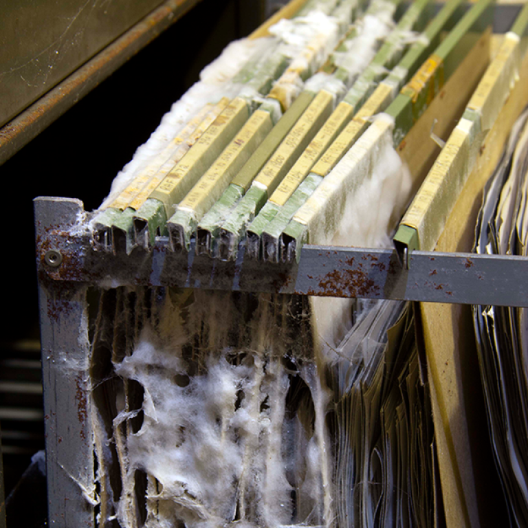
The photos were taken to create maps, but as satellites came to take over the tasks of mapping and imaging the earth's surface, aerial photography became less and less important. Eventually, the Directorate of Overseas Surveys ceased operations, film negatives were dispersed to the countries they covered, and two print collections were archived. But the museum holding one of the archives ran into financial and legal difficulties. The aerial photos were stored in damp basements, some photos were affected by mold, and the entire archive was nearly destroyed. The National Collection of Aerial Photography (NCAP) in Edinburgh took custody of the archive and moved it into safe storage conditions. But there was no funding available to digitize the archive and make it accessible for research. And scanning the archive manually could take many years.
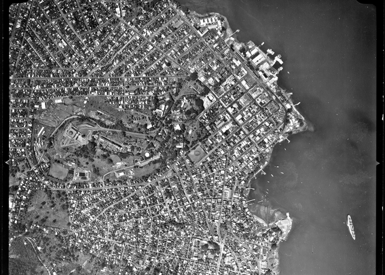
A gold mine for researchers
This vast archive of aerial photographs, covering parts of the world which often lack other historical records, is a gold mine for researchers. The photos show cities, villages, road networks, forests, and cultivated land, to name just a few examples. Since the photos were taken over 60 years, it is possible to see how human influence has changed a large part of the earth’s surface. But the photographs needed to be digitized in order for researchers to gain widespread access to the archive.
After hearing about the archive, Andreas Madestam, together with Anna Tompsett, also an economist at Stockholm University, realized the enormous potential that existed in this archive, not least for research in their own field of development economics. They also realized that significant resources would be needed to get the archive digitised.
Grants to digitise the archive
With an international team of collaboators, Andreas Madestam and Anna Tompsett began to plan how the archive could be digitised and made available for research, and applied for funds to digitise the archive. In 2017, they were awarded almost SEK 11 million from the Swedish research financier Riksbankens Jubileumsfond for the digitisation of the aerial photographs. In 2020, they were granted an additional almost SEK 53 million from the same financier to continue digitisation and begin research on historical development based on the aerial photos.
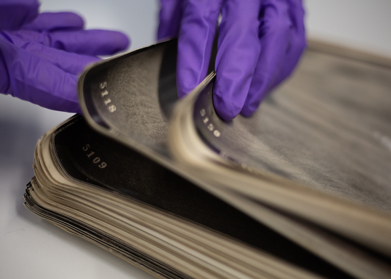
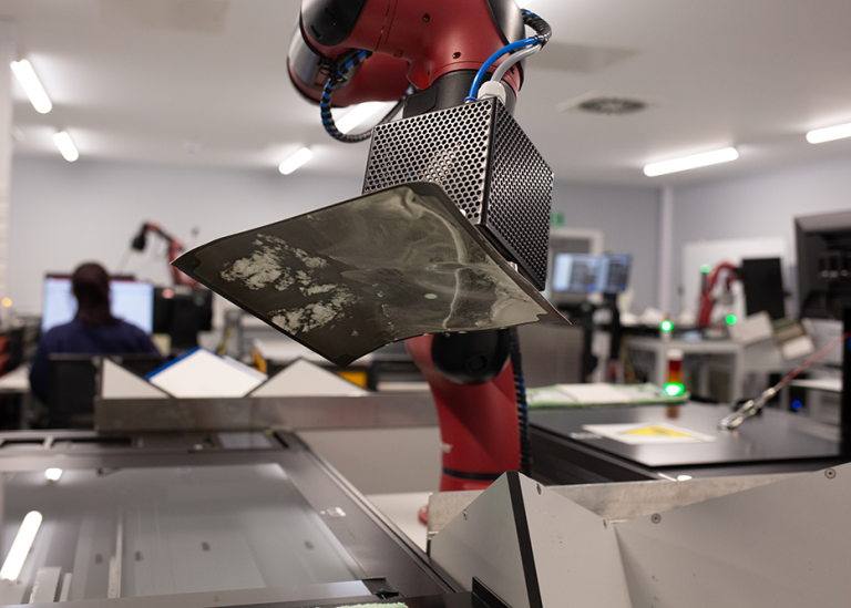
10,000 photos scanned every day
 The robotic arms have lifted one aerial photo after another into the scanner, where the photo has been scanned and digitized. Photo: National Collection of Aerial Photography
The first research grant made it possible to develop new digitization techniques. This is where the seven robots in Edinburgh enter the story. Adapting technology from the food production industry, robotic arms lift one aerial photo after another onto the scanner to be digitized. At maximum production, almost 10,000 aerial photos were being scanned every single day. In September 2023, the last of the nearly 1.8 million aerial photos was scanned. Researchers from Berkeley, Caltech, Stanford, and MIT are collaborating with the Stockholm team to process the images.
The individual aerial photos must be combined into a larger mosaic to make it possible to get an overview of what a city or region looked like. Algorithms and machine learning are important tools in the work of putting the images together. The team of 18 researchers and collaborators involved in the project includes experts in machine learning. By the end of 2024, the team expects to have successfully geolocated each image in the archive on the earth’s surface.
Access to large amounts of data
For a research project, this is a little special, according to Andreas Madestam. In the first stages, the focus has been on digitising the aerial photos and converting them into data that can be used. But the eventual goal is for the researchers to use this data to answer new research questions. In parallel with digitization, the researchers are therefore planning how the data can be used.
"The project is giving us access to such a vast amount of data. This is a strange situation for a researcher, especially when we study history. Mostly we have tiny amounts of data, and we have to think creatively about what we can learn from them. Here, there are just so many possibilities. We have to ask ourselves what the most important questions are that we should focus on," says Andreas Madestam.
Great potential in development research
In development research and economics, Andreas Madestam and Anna Tompsett see great potential for using the scanned aerial photos to study population density, urbanization, and where and how wealth has grown. The team is also creating maps of land use. Spatial resolution is high, allowing individual buildings and even vehicles to be distinguished.

Photo: Sören Andersson
"We can produce examples of places that have seen radical changes caused by humans, such as oil wells, mines, etc. The photos help document what some people call the Anthropocene, the era when the dominant force shaping the environment is the human race,” says Anna Tompsett.
The extraordinary detail displayed in the aerial photos reveal may also be of interest to, for example, geologists, historians, archaeologists, ecologists, cultural geographers and climate scientists.
Free access to data
A key project goal is to increase access to the archive. The mosaicked images will be made freely available for all non-commercial uses under Creative Commons licensing, while other data outputs, such as historical land use maps, will be made available for unrestricted use under Creative Commons licensing.
Study on the Caribbean
This autumn, the first study using these aerial photos will be complete. It focuses on the Caribbean and highlights the long-term interplay between social, economic, and ecological systems after decolonization. The new data show that urbanisation and restoration of forest ecosystems has occurred simultaneously, illustrating that human development does not necessarily entail negative ecological consequences. By the end of this year, the research team also plans to release data along with several other research papers that are currently in development.
Read more on the project page
Read about The Directorate of Overseas Surveys (DOS)
Aerial photos – gold mine for researchers


Last updated: October 1, 2024
Source: Communications Office