Research group NG| Hydrogeodesy Lab
By using geodetic methods to measure or infer hydrological quantities and their changes over time, Hydrogeodesy supports hydrological monitoring, management, and research via measurements that standard hydrological observations cannot obtain.
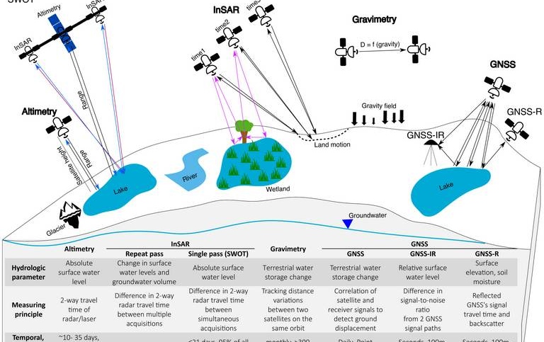
While most hydrological observations are point measurements of hydrological variables, such as water level or soil moisture, hydrogeodetic observations are obtained indirectly from geodetic data. These data are then translated to hydrological quantities, such as terrestrial water storage, snow depth, and surface water level. Hydrogeodetic studies that address hydrological problems beyond technical developments, such as those aiming to understand hydrological and geomorphological processes or human impacts are scarce. Hence, we use optical and SAR observations, interferometric SAR (InSAR), and altimetric data, in combination with hydroclimatic frameworks and artificial intelligence, to understand these processes and address key sustainability and water-related science challenges.
Group description
Hydrogeodesy is the discipline that uses satellite-based geodetic observations to understand changes in water availability, distribution, and movement (Jaramillo et al., 2024). We aim to go beyond the typical technical uses of hydrogeodetic techniques to address the goals of key hydrological and sustainability science frameworks and water management.
Publications:
Jaramillo, F., Aminjafari, S., Castellazzi, P., Fleischmann, A., Fluet-Chouinard, E., Hashemi, H., et al. (2023). The Potential of Hydrogeodesy to Address Water-related Problems and Sustainability Challenges (preprint). Preprints. https://doi.org/10.22541/au.170379692.29590839/v1 . In Review.
Aminjafari, S., Brown, I., Chalov, S., Simard, M., Lane, C.R., Jarsjö, J., Darvishi, M., Jaramillo, F., 2021. Drivers and extent of surface water occurrence in the Selenga River Delta, Russia. Journal of Hydrology: Regional Studies 38, 100945. https://doi.org/10.1016/j.ejrh.2021.100945
Darvishi, M., Destouni, G., Aminjafari, S., Jaramillo, F., 2021. Multi-Sensor InSAR Assessment of Ground Deformations around Lake Mead and Its Relation to Water Level Changes. Remote Sensing 13, 406. https://doi.org/10.3390/rs13030406
Jaramillo, F., Aminjafari, S., Castellazzi, P., Fleischmann, A., Fluet-Chouinard, E., Hashemi, H., Hubinger, C., Martens, H.R., Papa, F., Schöne, T., Tarpanelli, A., Virkki, V., Wang-Erlandsson, L., Rio, R.A.D., Borsa, A.,
Destouni, G., Baldassarre, G.D., Moore, M.-L., Posada-Marín, J.A., Wdowinski, S., Allen, G., Argus, D., Elmi, O., Fenoglio, L., Frappart, F., Huggins, X., Kalantari, Z., Munier, S., Ángel, S.P.-, Robinson, A., Rubiano, K., Siles, G., Simard, M., Song, C., Spence, C., Tourian, M.J., Wada, Y., Wang, C., Wang, J., Yao, F., Berghuijs, W.R., Cretaux, J.-F., Famiglietti, J., Fassoni-Andrade, A., Fayne, J.V., Girard, F., Kummu, M., Larson, K.M., Maranon, M., Moreira, D.M., Nielsen, K., Pavelsky, T., Pena, F., Reager, J.T., Rulli, M.C., Salazar, J.F., 2023. The Potential of Hydrogeodesy to Address Water-related Problems and Sustainability Challenges (preprint). Preprints. https://doi.org/10.22541/au.170379692.29590839/v1
Jaramillo, F., Brown, I., Castellazzi, P., Espinosa, L., Guittard, A., Hong, S.-H., Rivera-Monroy, V.H., Wdowinski, S., 2018. Assessment of hydrologic connectivity in an ungauged wetland with InSAR observations. Environ. Res. Lett. 13, 024003. https://doi.org/10.1088/1748-9326/aa9d23
Liu, D., Wang, X., Aminjafari, S., Yang, W., Cui, B., Yan, S., Zhang, Y., Zhu, J., Jaramillo, F., 2020. Using InSAR to identify hydrological connectivity and barriers in a highly fragmented wetland. Hydrological Processes 34, 4417–4430. https://doi.org/10.1002/hyp.13899
Palomino-Angel, S., Anaya-Acevedo, J.A., Simard, M., Liao, T.-H., Jaramillo, F., 2019. Analysis of Floodplain Dynamics in the Atrato River Colombia Using SAR Interferometry. WATER 11, 875. https://doi.org/10.3390/w11050875
Palomino-Ángel, S., Vázquez, R.F., Hampel, H., Anaya, J.A., Mosquera, P.V., Lyon, S.W., Jaramillo, F., 2022. Retrieval of Simultaneous Water-Level Changes in Small Lakes With InSAR. Geophysical Research Letters 49, e2021GL095950. https://doi.org/10.1029/2021GL095950
Peña, F.J., Hübinger, C., Payberah, A.H., Jaramillo, F., 2024. DeepAqua: Semantic segmentation of wetland water surfaces with SAR imagery using deep neural networks without manually annotated data. International Journal of Applied Earth Observation and Geoinformation 126, 103624. https://doi.org/10.1016/j.jag.2023.103624
Piemontese, L., Castelli, G., Fetzer, I., Barron, J., Liniger, H., Harari, N., Bresci, E., Jaramillo, F., 2020. Estimating the global potential of water harvesting from successful case studies. Global Environmental Change 63, 102121. https://doi.org/10.1016/j.gloenvcha.2020.102121
Group members
Group managers
Fernando Jaramillo
Universitetslektor, Docent

Members
Clara Hübinger
PhD student

Fernando Jaramillo
Universitetslektor, Docent
Jesus Martin Maranon Eguivar
PhD student
Francisco Pena
Postdoctor
Abigail Elizabeth Robinson
Doktorand

Saeid Aminjafari
Doktorand
